Porto-North-Portugal.com
The best independent guide to north Portugal
Porto-North-Portugal.com
The best independent guide to north Portugal
The Serra da Estrela by Car: A One-Day Driving Tour
The Serra da Estrela mountains contain some of the most dramatic and wild natural scenery in all of Portugal. This is a region of towering granite peaks, deep glacial valleys, and remote mountain villages, and includes Torre, the highest point in mainland Portugal at 1,993m.
A car is essential for exploring the vast and rugged landscapes of the Serra da Estrela. The region is crossed by well-maintained mountain roads that wind through spectacular scenery and climb all the way to the highest summits, making it a fantastic destination for a road trip.
While you could spend days exploring the area, it is possible to experience many of the highlights in a single, well-planned day of driving. This guide provides a suggested one-day itinerary, detailing a route that covers the most stunning roads and key sights of the region.
Related article: The Beira region
Highlights of a driving day tour of the Serra da Estrela
The spectacular Zêzere Valley carved out by an ancient glacier
Linhares da Beira, a delightful hilltop village with an imposing castle and traditional stone houses
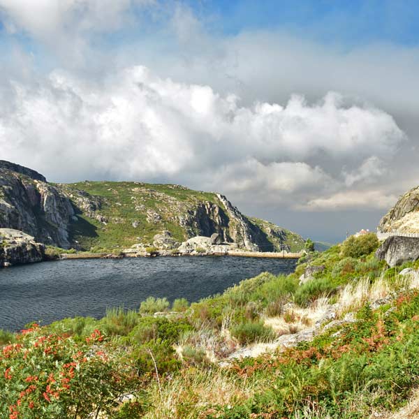
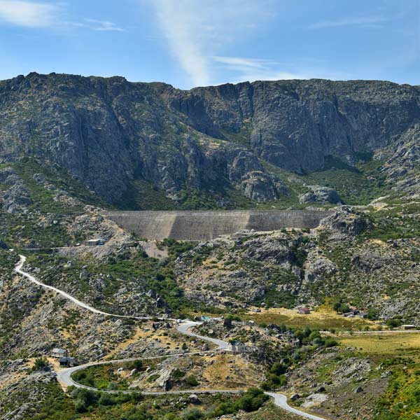
The scenic mountain lake of Covão do Curral (image above) and the Comprida reservoir
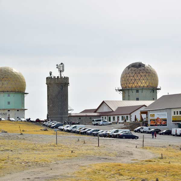
Torre - The plateau summit of Serra da Estrela and the highest point of Portugal. Torre is actually a bit of a bleak place, with two ageing radar domes and a tourist shopping centre, but as it is the highest point, you will want to visit.
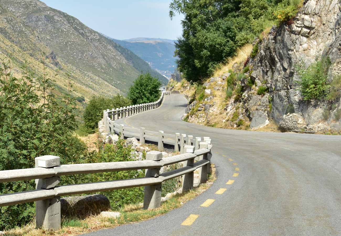
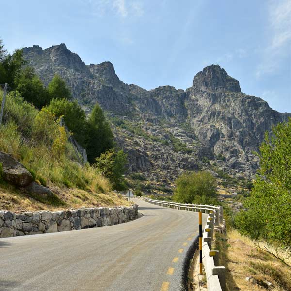
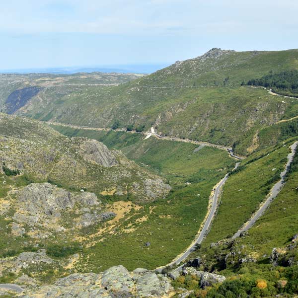
Over 60km of stunning mountainous roads, with every twist providing unique landscapes and picturesque views. This image is of the roading leading down the Zêzere valley to the town of Manteigas
A suggested 1-day tour of the Serra da Estrela
Below is the recommended 1-day driving route of the Serra da Estrela. The route, marked in green, begins in the village of Linhares and ends Zêzere valley. The most scenic sections of the driving tour are highlighted in red, while the grey markers show additional sights and the optional drive to Manteigas
Sights of the route: 1) Linhares (village) 2) Folgosinho (village) 3) Gouveia (town) 4) Sabugueiro (village) 5) Covão do Curral lake 6) Comprida reservoir 7) Torre summit 8) Senhora da Boa Estrela 9) Mirador do Vale Glaciar viewpoint 10) Covão d'Ametade 11) Vale Glaciar do Zêzere 12) Manteigas (town) 13) Penhas da Saúde (village)
Note: Details of the entire route are given towards the end of the article
Warning: This driving tour is only from May to October when the weather is good. Always check the weather before departing as the Serra da Estrela mountains can have very changeable and unpredictable weather. We strongly advise against driving in the mountains if there is any chance of frost or snow - which can drift extremely high due to the strong winds.
For details about skiing in the Serra da Estrela, please see the official website http://www.skiserradaestrela.com
Why this route through the Serra da Estrela?
This route covers the best of the region, which can be realistically fitted into a single day of sightseeing.
The day begins in the pretty foothill villages of Linhares and Folgosinho; the morning is the best time to visit them when there are the fewest tourists and they are at their most tranquil.
The route has been designed so that the standard of the natural scenery is constantly improving throughout the day, and ends with the most spectacular landscapes (the section between the Torre peak to the Zêzere glacier valley). It is a shame to begin the day with the highlight, and then everything else is not as impressive.
All of the designated roads are of a high standard (wide enough for two cars to pass and lined with safety barriers on treacherous sections), there are no dirt or very narrow roads.
The larger towns of Covilhã, Seia and Manteigas are not included, but could be visited if you have longer in the region (though Viseu, Guarda, Monsanto and Trancoso are all much more historic and characterful).
The largest town on the route is Gouveia, and visiting this charming town could extend the day trip. Locations to stop for lunch could be in the touristy village of Sabugueiro, pretty Gouveia, or nondescript Penhas da Saúde.
The Torre Peak
Everyone is drawn to the Torre peak as it is the highest point in Portugal, but in actual fact, it is a bit disappointing.
Instead of being a clear summit, it is a wide and flat plateau on which two ageing radar domes were constructed along with a tourist-focused shopping arcade. The actual summit (at 1993m) is in the centre of a large roundabout and is marked by a 7-meter-high stone pillar, just to make the point 2,000m!
Torre is only 520m from the main road (the N339), so we recommend driving in, seeing it, then heading onto the much more scenic areas to the south-east, and returning later if you have time.
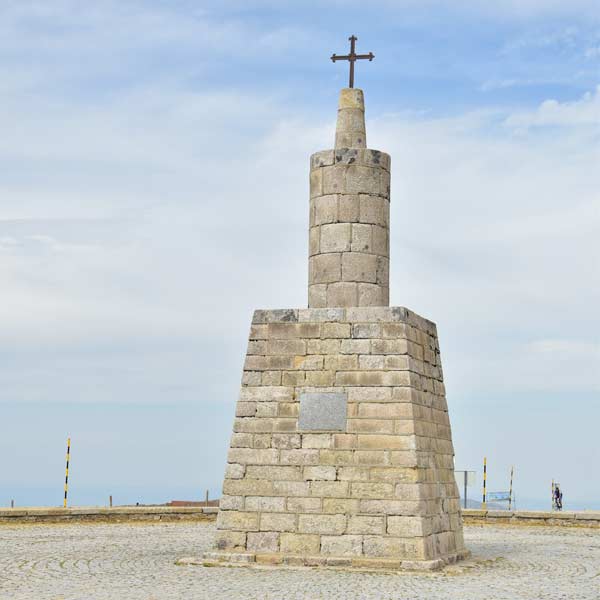
The marker for Torre peak sits within a roundabout…..
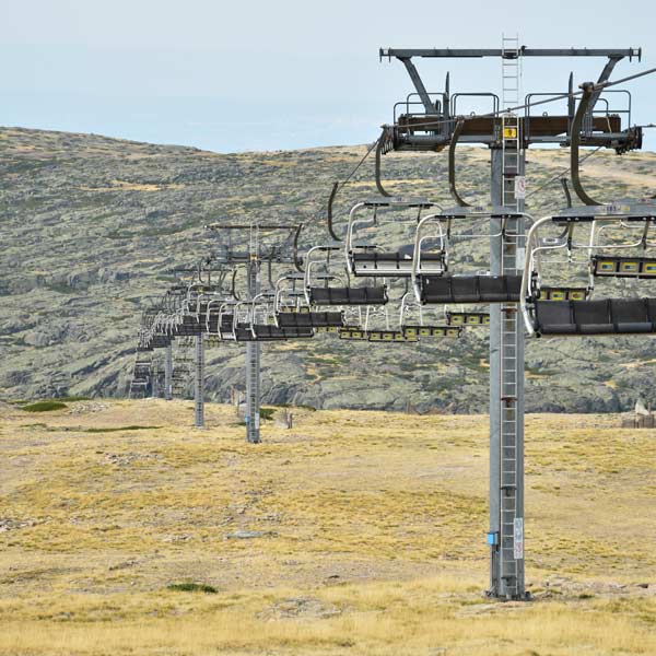
The bitterly cold winters and reliable snow, have made Torre a centre for skiing, but in the summer the disused cable car adds to the bleakness of the region.
Details of the driving route
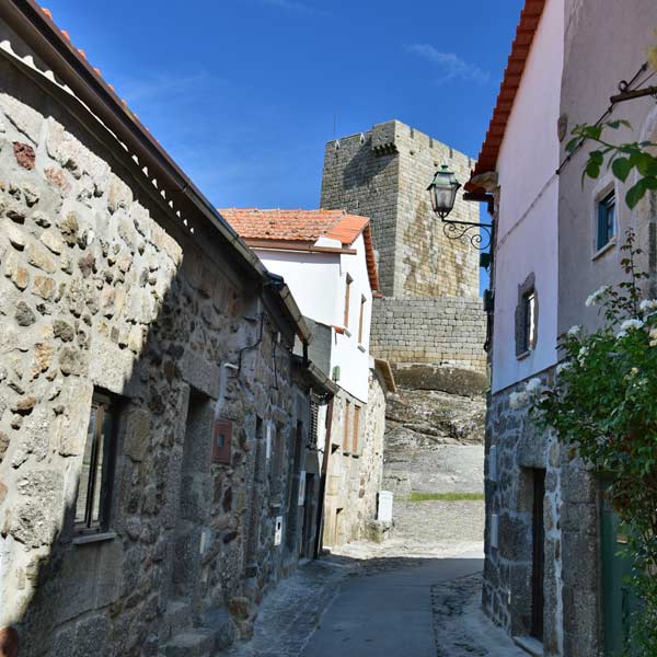
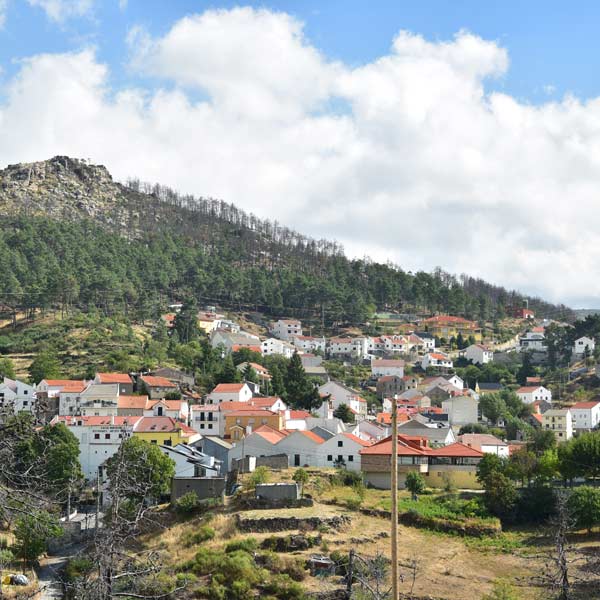
Linhares
Linhares is a delightful medieval village set on the northwestern foothills of the Serra da Estrela. Within the village, cobbled streets lined with traditional rural granite houses meandering up to the impressive castle. Linhares is extremely charming and will be one of the highlights of the day trip.
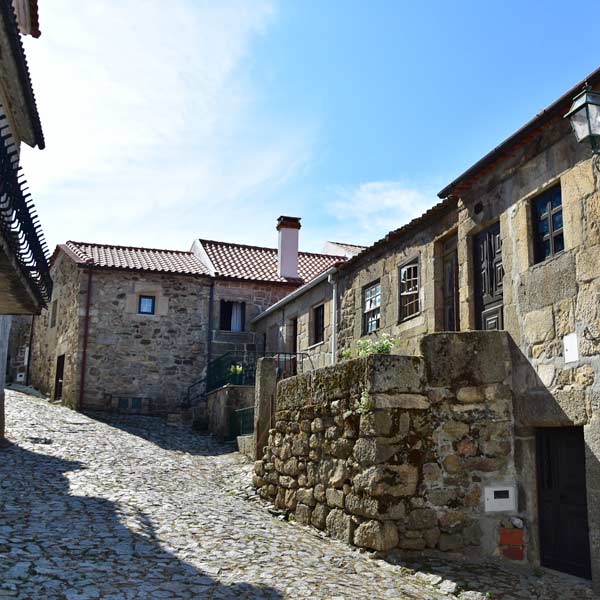
The appearance of Linhares has barely altered in 500 years
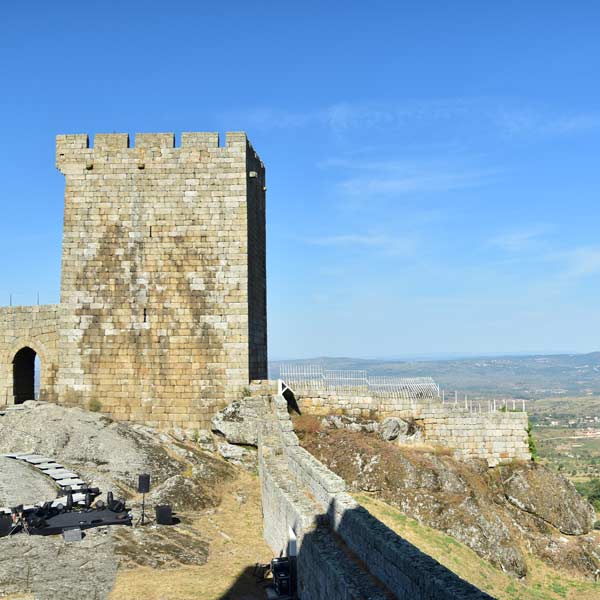
The Castelo de Linhares with its views over the entire western Beira region
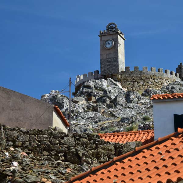
Folgosinho
Folgosinho is another charming village, which perches on top of a craggy hill. The unique building of the village is the stone watchtower that stands at the top of the rock outcrop.
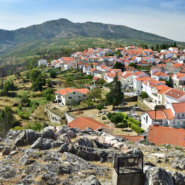
The view over Folgosinho from the watchtower
It is quite a climb to the top of the tower
Gouveia
Gouveia is a pretty town, of parks, plazas and views into the mountains. At the centre of the town is the Igreja de São Pedro church, with its exterior lined with blue and white tiles.
After Gouveia, the road starts to climb into the mountains and offers some wonderful viewpoints looking westwards. Along the route is the Cabeça do Velho (Old man's head) rock feature.
Advice: The N232 eventually leads into the town of Manteigas, but the final section of the road has so many twists and switchbacks that it is best avoided (the road takes 15km to travel just the 1 km down the hill!). We suggest turning off before and heading to Sabugueiro.
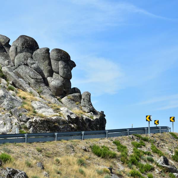
The Cabeça do Velho, supposedly this looks like an old man….….
Sabugueiro
Sabugueiro is famous within Portugal as being the highest village in the country (1,250m).
The village originally sheltered shepherds and their sheep, to avoid the harsh winters on the upper slopes. Today Sabugueiro has a very touristy atmosphere, but is the best location for lunch, before heading into the more remote mountains.
Insight: The region is famous for Quejio Serra da Estrela, a cheese produced from sheep's milk. In Sabugueiro there will be many shops selling this delicious cheese.
Apart from being very high up, Sabugueiro is not dissimilar from many other Portuguese towns
The reservoirs and lakes
After Sabugueiro, the road twists and climbs through the treeline to some barren but dramatic landscapes.
Within these windswept peaks are three reservoirs. The first lake to drive past is the Covão do Curral, and this one provides the most beautiful scenery. The road then runs along the base of the massive Marques da Silva dam, which holds back the largest body of water, the Lagoa Comprida. The third reservoir is the Covão do Forno and is reached via a scenic hiking trail from Comprida lake.
At the dam is a car park and this leads to a stone beach (known as the Praia da Lagoa Comprida) where it is possible to swim in the freezing waters.
Insight: The Covao dos Conchos, with its famous flora covered bell-mouth spillway, is a 1-hour hike from Comprida lake.
The lakes are man-made to provide hydroelectricity, a reliable source of freshwater and to control the springtime snowmelt
Torre
After passing the Serra da Estrela ski resort (which can be missed as it is positioned lower than the road) the road climbs to the junction with for Torre. As indicated above, you will want to see the Torre complex but will probably leave a bit underwhelmed.
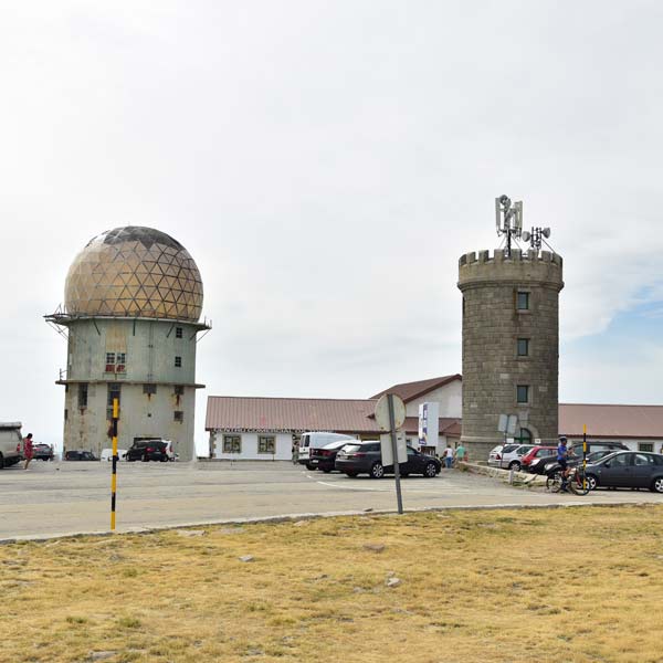
Torre is not much to look at….
West of Torre and to the Zêzere valley
Some of the most spectacular scenery of the Serra da Estrela is found to the west of the Torre plateau.
Advice: This area is the most popular for sightseeing, but as it is so mountainous, there are few decent pull-ins or car parks. For the tour, we suggest driving through the area twice; once downhill to Covão d'Ametade (or the town of Manteigas) and then uphill, on the return to your accommodation (via the town of Seia and the N17)
The first feature along the road is the Cântaro Magro, a craggy granite outcrop, which can be viewed from the pull-in on the N339 road.
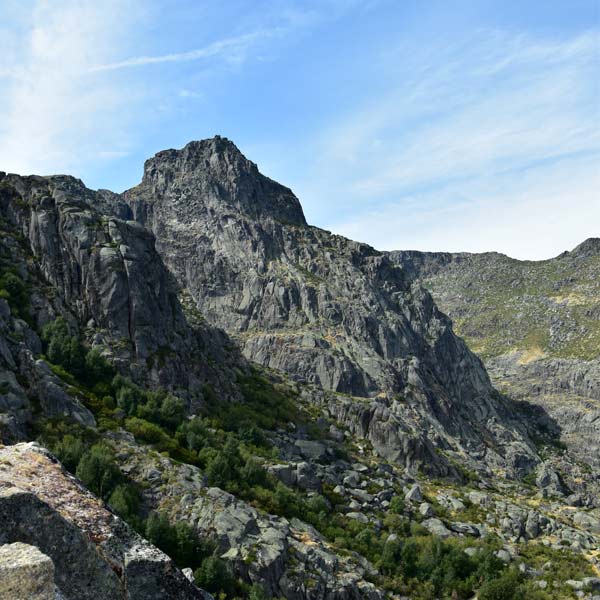
The Cântaro Magro, one of the most challenging climbing peaks in the Serra da Estrela
Slightly downhill is the Senhora da Boa Estrela, an image of Mary carved into the side of a granite cliff face. The carving dates from 1947, and is of the patron saint of the shepherds who worked these inhospitable lands.
The Nava de San Antonio is a flat plateau between the steep Alforia valley (to the north) and the Zêzere valley (south). The glacier which once covered the plateau pushed the boulders from the central grasslands and condensed them on the northern side. Tilting at the top of the ridge is the massive Poio do Judeu, the largest bolder in the Serra da Estrela.
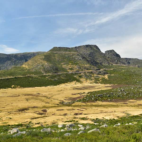
The Nava de San Antonio, with the Cântaro Magro to the right and the peat grasslands on the left
The Alforia valley drops steeply down from the Nava de San Antonio and high above the valley is the Padre Alfredo dam and lake.
The Padre Alfredo dam
Once driven around the Nava de San Antonio turn left (northwards) towards Manteigas, which then drops down into the Zêzere valley. 20,000 years ago this "L" shaped glacial valley had an ice thickness of over 300m and extended for almost 7.5km.
Today, huge boulders are scattered through the deep valley, and a stream (the Rio Zêzere) runs the length.
Looking down into the Zêzere valley
Covão d'Ametade is a rustic camping site set amidst dramatic natural scenery, and there is a pleasant short walk to the Nascente do Rio Zêzere (source of the river Zêzere). There is also a large car park which also helps!
The day trip could be extended by continuing down the valley to Manteigas, but the road narrows and all of the best natural scenery as at the top of the valley.
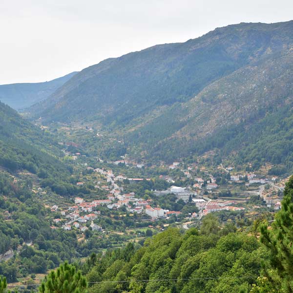
The town of Manteigas looking up the Zêzere valley
End of the Serra da Estrella tour
To leave the Serra da Estrela, the best route is along the N339 either west to Seia or east Covilhã. The N232 east from Manteigas to Belmonte is another good road, but it ends on the eastern side of the Serra da Estrela.
Advice: The N232 to the west has so many switchbacks and turns it is best avoided.
Our most popular guides to northern Portugal


Expert Insight: These guides are curated by Philip Giddings, a travel writer with over 25 years of local experience in Portugal. Since 2008, Phil has focused on providing verified, on-the-ground advice for the Porto and North Portugal region, supported by deep cultural ties through his Portuguese family. Read the full story here.
 -
-


If you've found our content valuable, we'd welcome your support.
The digital publishing landscape has evolved significantly. As a small independent publisher, we face growing challenges. Search engines increasingly favour paid content over organic results, while AI-generated content often reproduces original work without attribution.
To support our work, please consider bookmarking this page (press Ctrl + D) for quick access. If you find an article helpful, we'd be grateful if you'd share it with friends on social media.
For specific questions, please see our Reddit community at r/LisbonPortugalTravel.
Should you notice any outdated or incorrect information, please contact us at [email protected]
Thank you for helping us continue to provide valuable content in an increasingly challenging digital environment.